This past summer, from July 29 to August 8, 2024, the Near Surface Geophysics Lab had the opportunity to join an ambitious field research project in Utqiagvik, Alaska. We teamed up with researchers from Penn State University, Dr. Ming Xiao and his master’s student Matt Hallissey, to investigate the rapid thawing of Arctic permafrost—an issue that’s becoming increasingly urgent as global temperatures rise. We spent ten days in the field, working to better understand the impacts of permafrost degradation on the environment and infrastructure in this vulnerable region.
Permafrost is frozen ground that has been stable for thousands of years. But as the climate warms, it’s starting to thaw, with potentially far-reaching consequences. Thawing permafrost can destabilize the ground, endangering local infrastructure, releasing stored carbon, and altering ecosystems. This joint research aims to map the spatial distribution of these thawing areas, identify where ice wedges—distinct features of the thawing process—are forming, and assess the risks posed to nearby communities.

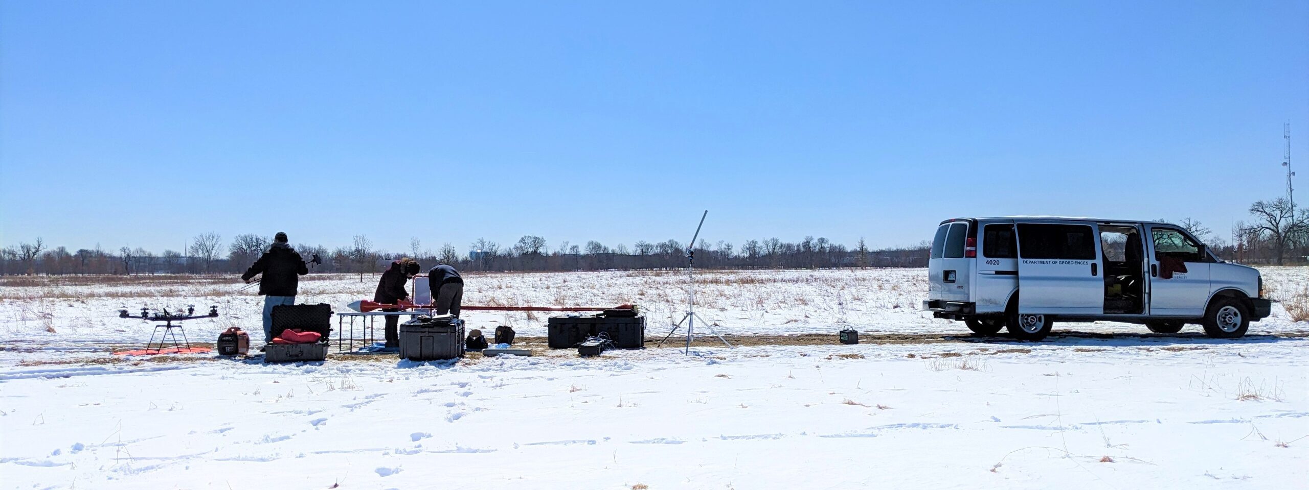
Airborne VLF-EM data over Arctic Tundra
To carry out this research, we deployed a suite of advanced geophysical instruments that allowed us to “see” beneath the surface without disturbing the delicate environment of the Arctic tundra. One of the key tools we used was Airborne Very Low Frequency Electromagnetic (VLF-EM) technology, which enabled us to map large areas quickly and effectively, capturing detailed information about the permafrost layers and their state of thaw. This airborne system gave us a bird’s-eye view of permafrost conditions across the landscape—something that would have been nearly impossible to do with traditional ground-based methods alone, given the vast scale of the tundra region.

Airborne GPR data being collected over the Arctic tundra
In addition, both airborne and on-ground Ground Penetrating Radar (GPR) data were collected to validate and complement the findings of the airborne VLF-EM data. The GPR provided detailed, high-resolution images of the subsurface, helping us identify areas of thaw and potential ice wedge formation. We also used Electromagnetic Induction (EMI) tools, such as the EM31, to gather more precise data on the electrical conductivity of the ground. This helped us understand the moisture content and distribution within the permafrost layers—key factors influencing thaw dynamics. By measuring how electrical conductivity changes in response to the presence of water, we gained valuable insights into how water is moving through the permafrost, which plays a major role in accelerating thaw.

Chanho Park collecting GPR data over Egasak Street.
Beyond the tundra, we focused on using Ground Penetrating Radar (GPR) to examine the coastal bluffs failures along Egasak Street. Coastal erosion is a growing concern in Utqiagvik, and we were especially interested in identifying areas where the bluffs were deteriorating due to thawing permafrost. Just a few years ago, Egasak Street was a two-lane road that ran almost the entire length of the Arctic coast on the northern side. However, rapid permafrost thawing has significantly weakened the slope stability in the area. By the time we visited in the summer of 2024, the road had been almost entirely eroded away, with visible fractures in the ground signaling further impending failures. As these failures continue to progress, the coastal bluff is now perilously close—just meters away—from residential and business properties along the coast.

Dr. Mine Dogan and Chanho Park work hard to collect GPR data in the Arctic Tundra
To better understand the failure planes and the conditions of the bluff, a measurement grid was set up to collected on-ground GPR data. GPR allowed us to look at subsurface conditions in detail, helping us identify structural weaknesses and potential threats to the surrounding infrastructure.
Our collaboration with Penn State University added an invaluable dimension to the project. With their expertise in Arctic permafrost, and our labs expertise in near surface geophysical tools, we were able to expand the scope of our research and refine our methods. It was truly a team effort, and we are grateful for the opportunity to work alongside such talented researchers. The exchange of ideas and data between our institutions not only strengthened the research but also fostered a deeper understanding of the challenges we face in the Arctic. By combining our efforts, we’re creating a more comprehensive model of how permafrost is changing and what that means for the future of the region. This partnership underscores the power of collaboration between leading academic institutions in advancing critical Arctic research.
As we analyze the data from our fieldwork, we’re gaining crucial insights into how permafrost thawing is altering the landscape in Utqiagvik. Our findings will guide future research and inform strategies to protect infrastructure and address climate-related risks. This project underscores the importance of advancing geophysical research in rapidly changing regions like the Arctic, where innovative, data-driven solutions are essential. We’re excited to continue collaborating with Penn State University to deepen our understanding of the complex processes driving Arctic change.
By Chanho Park